One Credit Does Not Equal One Acre: Calculating Mitigation Banking Credits in Florida
Wetland mitigation banking credits are a valuable commodity. However, the methodology behind calculating credit amounts can be confusing and often leads to misconceptions about how many acres equal a wetland credit. This is to say nothing of how habitat credits are calculated.
The calculation of credits in Florida is not a straightforward mathematical formula. The exact formula may vary based on the method and regulations used. However, it is always influenced by size, location, and functional value of each proposed site.
How many acres is a wetland credit?
One common misconception is that one wetland credit equals one acre of land. However, that is not always the case. The value of a wetland credit is not tied to a specific number of acres. Instead, it’s based on the quality and functional value of the wetland or habitat.
In fact, although the size of the impact is an important part of calculating how many mitigation credits to offset an impact, it’s only one of a few factors to consider. One credit does not equal one acre; it’s a spectrum.
How to set a mitigation ratio for calculating mitigation credits
A wetland or habitat credit represents the value of a specific type and amount of wetlands or habitat. This is usually expressed in units such as acreage or habitat units (HU).
As a developer, the relative loss of function at your impact site will be compared to the relative gain of function at your bank of choice. These assessments will dictate how many credits you will need to buy and partially determine at what cost.

- Relative Lift: how will the ecosystem at the mitigation bank function by the end of the monitoring period compared to where it started AND
- Relative Loss: how much function will be lost at the impact site?
In order to make this comparison, regulatory agencies rely on impact or mitigation ratios comparing both sites. They also take into account initial baseline surveys and expected outcomes of construction. Mitigation requirements and risk factors are some of the other considerations.
The data collected for the mitigation ratio determines how many credits are assigned per “unit” of impact. The “mitigation ratio” ensures that there is “no net loss” of function. This helps determine that a developer is paying for an appropriate level of ecological compensation. It also ensures that the banker is rewarded properly.
Two approaches to calculating mitigation credit amounts
Regulatory agencies in different jurisdictions use different methods of calculating mitigation credit amounts. However, they generally fall into two categories: a standard formula to apply to all permits & a case-by-case evaluation with more flexibility and discretion.
- With the first method, credits are compared to tables combining multiple data points into a single collective dataset. This groups sites into categories of impact. This is used for the Ratio Method and species credits.
- With the second method, your unique functional values are compared based on an in-depth assessment & precise measurements. The UMAM is usually the methodology used in this case.
In both situations, the functional value of an impact site and its prospective mitigation bank site are compared. Only, one method is more precise and compares more data points.

Factors like functional evaluation, best professional judgment, and agency policies and regulation go into creating the ratio. With the aggregated data, these factors influenced the creation of the table when it was made. For individual assessments, those factors are applied on a case-by-case basis, allowing for more targeted data use and flexibility.
The methods behind mitigation credit calculations: UMAM, Ratios, & Habitat Suitability
In Florida, they use the Ratio Method when more precise measurements of data collection are not available. With the ratio method, your credits are put into brackets: low, medium, or high ecological value for wetland credits. That gives you a base ratio. This base ratio is multiplied by the area affected and gives you the number of credits.
For calculating species credits, each animal has its own protocol for measurement. However, they also rely on a comparative method to calculate credits. They measure functionality with the Habitat Suitability Value (HSV), which quantifies the habitat’s ability to support the species. The HSV is assigned to different types of habitat.
To calculate the habitat units, the HSV for each habitat type is multiplied by the acreage of that habitat, This is then multiplied by a base ratio and a landscape multiplier to account for landscape factors that may affect the habitat.
The UMAM (Unified Mitigation Assessment Method) uses a more site-specific, data-driven approach to assess the ecological value of a wetland or habitat and determine a mitigation requirement. It considers various factors such as habitat quality, location, and regional context to provide a more accurate representation of the ecological value of a site.
How does credit amount affect credit price?
When you go out on the market to look for credits to buy or sell, you will be comparing the value of your habitat units to the value of the ones you find. The relationship between the quality of the wetland and the cost of mitigation credits is often determined through a mitigation credit pricing structure.
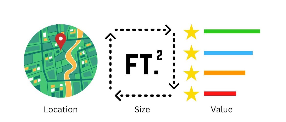
Steps for calculating mitigation credits: size, location & function
Working already inside of Florida jurisdictions, a mitigation sales broker can advise you quickly on credit amounts needed because they are deeply familiar with how each water management district and the FDEP calculates.
If you have a property that needs mitigation, you need three points of information to see what credits are available to offset your impact and how much they cost. With this information, you can come to a mitigation sales broker, like us, to estimate the costs for your development project or evaluate the value of possible land for a mitigation bank.
- Location: address, parcel ID, vicinity
- Size: estimated acreage or square feet of the impact
- Functional value: UMAM Score (0-1)
We use this information to quote a budget for your compensatory mitigation and find you available credits.

With your location, we look up the drainage basin or recovery unit that your impact falls under. The area of the habitat helps determine the value of the land, while the location determines which service area or recovery unit the habitat lands in. For species credits, the location tells us which habitat zone your site falls in.
The estimated acreage gives us two pieces of information–size and habitat type. You might be impacting a quarter acre of palustrine forested wetlands and a half acre of sand skink habitat. With this information, we are able to compare the size of the impact and the availability of “in-kind” credits.
We need the functional value of your habitat in order to help you set a credit price and amount. There are many types of functional assessment for the wetland ecosystem and especially for species conservation.
Key surveying techniques used to calculate mitigation credits
The location and size are determined by habitat delineation and habitat ID assessments. During these assessments, a technician typically uses a combination of field observations, remote sensing imagery, and mapping techniques to identify the boundaries of the specific habitat type. These surveys are done in parallel.
Once the habitat ID and delineation take place, the next step is an evaluation of the functionality of the ecosystem. This assessment provides information on the ecological values of the area, such as the presence of threatened or endangered species or the presence of rare or unique habitats.

Factors to consider when calculating mitigation credits
In these assessments, scientists are looking for ecologically important areas, fragmentation, habitat zones, and other habitat management concerns. Heavily degraded sites will be awarded more credits for achieving functionality. Highly functional and ecologically important sites will likely be denied permits.
Government officials have discretion in assigning a “multiplier” to ecologically important areas, like with the Florida Panther Conservation Bank.
These factors have a huge impact on how we calculate mitigation credits. They also give us landscape context, like the characteristics of the surrounding landscape and how it is used by an animal. They base the landscape multiplier on this data.
The importance of accurately calculating mitigation credits
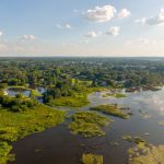
Calculating wetland mitigation banking credits can be a complex process, but it is essential for ensuring that wetlands are protected and restored in a sustainable manner.
As we’ve seen, the exact formula for calculating these credits can vary based on the method and regulations used. However, it is always influenced by the size, location, and functional value of each proposed site. It requires the input of ecological consultants, regulatory agencies, and field scientists to determine.
With the help of a mitigation sales broker, you can find available credits that suit your needs while compensating accurately.