Navigating Florida Land Use and Cover with FLUCCS Codes
The Florida Land Use and Cover Classification System (FLUCCS) is a comprehensive and standardized system for classifying and mapping the land use and cover of the state of Florida. Developed by the Florida Department of Environmental Protection (FDEP), FLUCCS provides a framework for understanding the distribution and patterns of land use and cover across the state, and serves as an important tool for managing and conserving Florida’s natural resources.
What is land use and cover?
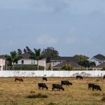
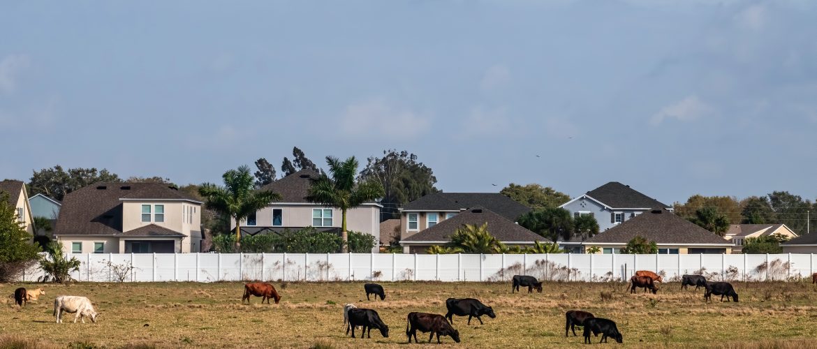
Land use refers to the way in which land is utilized by humans. It encompasses a wide range of activities including residential, industrial, commercial, agricultural, recreational, and conservation-related uses. It also includes activities such as mining, forestry, and urban development.
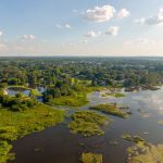
The concept of land use is closely linked to land cover, which refers to the physical characteristics of the land surface, such as vegetation, water bodies, or urban structures.
Land use and land cover are often studied together as they are closely interrelated. Land use decisions can change the land cover, and changes in land cover can affect how land is used. Land use planning is the process of regulating the use of land in an effort to promote socially and environmentally sustainable development.
Purpose of the Florida Land Use and Cover Classification System
To set a reliable fungible asset market, the mitigation banking industry needs standardized units of measurement and classification. One of these standardized measurements is a methodology for coding habitats. In Florida, this coding system is the FLUCCS system, Florida Land Use Cover and Forms Classification.
Using a combination of remote sensing data and ground-based observations, FLUCCS maps and classifies land use and cover into more than 30 different categories, including urban, agricultural, wetlands, forests, and water bodies.
This level of detail allows for a more accurate understanding of the distribution and patterns of land use and cover, and provides valuable information for resource managers and planners.
FLUCCS helps monitor and evaluate land use planning over time
The system also allows for the collection of data on land use and cover changes at regular intervals, providing valuable information for understanding the impacts of changes over time. This helps support a range of important management and conservation activities, including wetlands and water resources management, biodiversity conservation, and climate change adaptation.
As mitigation banking is part of an overall plan for land use in Florida, categorizing potential bank sites and permit sites with this system is a necessity. It helps integrate the industry with other land use plans, like the Florida Comprehensive Wildlife Conservation Strategy or the Southeast Florida Regional Climate Change Compact.
How would an environmental manager use Florida land use codes?
FLUCCS codes are approved by the regulatory agencies in Florida and are widely used in the state. An environmental manager can conduct a site survey to identify the current land use and cover of an area, and then use FLUCCS to classify the land use and cover. This can inform the development of a workplan for a proposed project.
In most cases, an environmental manager would need to use FLUCCS in the permitting paperwork. This information would be used by regulatory agencies such as the FDEP to determine whether the project complies with relevant regulations and guidelines.
Additionally, an environmental manager may be required to submit a mitigation plan, which outlines the measures that will be taken to minimize or offset any negative impacts of the proposed project on the environment. The mitigation plan would also provide information on how FLUCCS was used to identify and evaluate potential mitigation opportunities.
An environmental manager can use FLUCCS to track the progress of a project. This can help to identify any unexpected or unintended consequences, and to make adjustments to the project as needed.
FDOT & the Department of Transportation’s FLUCCS manual
The Florida Department of Transportation (FDOT) FLUCCS manual is a guide for the use of FLUCCS codes and their application in transportation planning, design and construction projects.
It includes information on how to apply FLUCCS codes to transportation projects, how to interpret the results, and how to use the information to make decisions related to project design, environmental impact assessment, and permit.
The manual also includes information on how to use FLUCCS codes in conjunction with other data and tools, such as GIS data, aerial photography, and field observations.
FLUCCS codes & code descriptions
When determining the appropriate land use code during a site survey or when filling out impact permit paperwork, an environmental manager can use a combination of remote sensing data, ground-based observations, and field measurements to identify and classify the land use and cover of an area.
Each FLUCCS code represents a specific land use or cover type, and is accompanied by a detailed description of the characteristics and attributes of that type.
For example, code 500 represents “Water Bodies,” and includes any land that is covered by water, such as lakes, rivers, and estuaries. The code description for this category would include information on the types of water bodies that are typically found within Florida such as coastal lagoons and freshwater ponds.
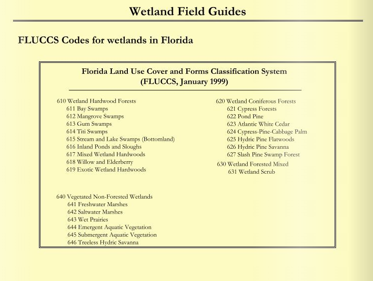
FLUCCS codes are primarily used to classify and map land use and cover types in Florida. However, certain FLUCCS codes can be used to identify and classify habitats based on their land use and cover characteristics. For example, FLUCCS code 600 (Wetlands) can be used to identify and classify wetlands habitats. Similarly, FLUCCS code 400 (Upland Forests) can be used to identify and classify forest habitats.
Florida land use codes help target specific ecological impacts
The Florida Land Use and Cover Classification System (FLUCCS) code can be used in conjunction with the other necessary assessments, like the Uniform Wetland Assessment Method (UMAM), to provide a more comprehensive understanding of the area.
For example, if a wetland site is classified as code 600 (Wetlands) by FLUCCS, the UMAM would then focus on the ecological functions of that wetland, such as hydrology, vegetation, wildlife and other characteristics.
If the site is located in an area classified as code 100 (Urban and Built-Up Land) by FLUCCS, the assessment would also consider the potential impacts of human activities on the wetland, such as urbanization and development.
The FLUCCS code can be used to contextualize the wetland site in the larger landscape and identify any potential connectivity or fragmentation issues, which can have significant impacts on the ecology of the wetland.
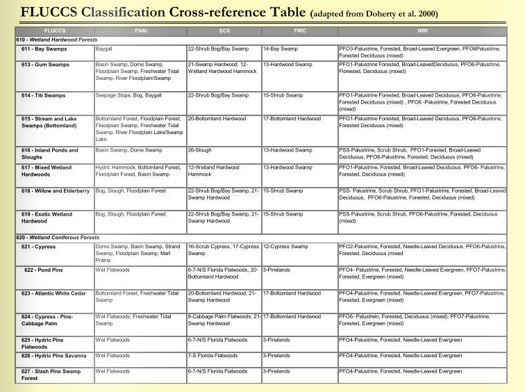
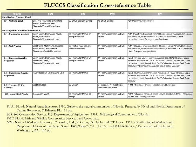
The FLUCCS Crosswalk helps communication and collaboration between agencies
A lot of different US agencies and environmental organizations have their own systems of land cover classification. For this reason, FLUCCS has a crosswalk that connects four different systems to the FLUCCS codes. This makes paperwork and communicating with other agencies a lot easier.
The crosswalk system helps facilitate collaboration between:
- The National Wetlands Inventory, which overlaps with the Cowardin system and sets the stage for credit classification in Florida;
- The Florida Natural Areas Inventory (FNAI), used for defining “community types” that exist within credit classifications;
- The Florida Fish and Wildlife Conservation Service (FWC), which regulates conservation and habitat banking; and
- The US Department of Agriculture’s Soil Conservation Service.
Finding Florida land use GIS data to make a Florida land use map
An environmental manager should document and report the results of the land use and cover classification in the impact permit paperwork. This can include a detailed description of the methods used to classify the land use and cover, as well as a map showing the distribution and patterns of land use and cover in the area.
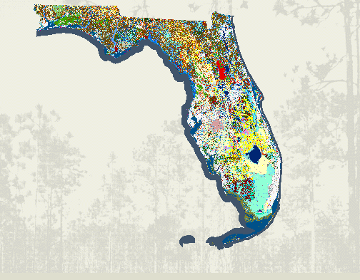
There are several ways to find a Florida land use map or GIS data, depending on the purpose and level of detail required:
- Online sources: There are several online sources that provide land use maps for Florida, such as The Florida Cooperative Land Cover Map (CLC), the Florida Geographic Data Library (FGDL) and the Environmental Protection Agency (EPA).
- State agencies: State agencies often have Florida land use maps available on their websites, like the The Florida Department of Environmental Protection (FDEP) Statewide Land Use Land Cover GeoSpatial Open Data map.
- Local governments: Local governments such as counties and municipalities may also have Florida land use maps available on their websites. These maps can provide detailed information on land use and zoning within a specific area.
- Create your own: It is also possible to create your own Florida land use map using GIS software and data sources such as satellite imagery, aerial photography, and field observations. This option is more time-consuming and requires specialized skills and knowledge, but it allows for a high level of customization and can provide more detailed and accurate information.
Once you have obtained the Florida land use GIS data, you can use GIS software to create custom maps and visualizations, analyze land use patterns, and perform spatial analysis. These tools can help you to identify areas of concern, evaluate potential impacts of development, and develop mitigation and conservation strategies.